1. What is the issue? Please be detailed.
ODK Central 1.5.2 via ODK Cloud
ODK Collect V2022.2.3
Item 1
I was looking at the geowidget values and noticed they are different depending on where they are stored/queried from,
- lat/long (raw/CSV) vs long/lat (Central/OData)
- discarding accuracy except in CSV
- adding delimited labels to points in CSV
- different number of significant figures for manual vs GPS
- SRID prepended to string and manual point elevation converted from 0.0 to 0 in OData
I found the Central WKT values are invalid when tested here but not here. One requires a Z if elevation is included, one won't accept a Z and neither accept a string prepended with SRID=4326;
Points:
Raw value in form: latitude longitude elevation accuracy using a note to display the string on screen, under the View/Change button it's in DMS and 1/2 dec places
- Manual placement
- -25.58161926676068 134.81799200177193 0.0 0.0
- GPS acquired (fewer sig figs)
- -25.5816192 134.8179920 90.30000305175781 13.451000213623047
Displayed in Central: POINT (longitude latitude elevation) Not a valid WKT string, should be POINT Z? precision not shown but indicated by # of significant figures?
- Manual placement
- POINT (134.81799200177193 -25.58161926676068 0)
- GPS acquired (fewer sig figs)
- POINT (134.8179920 -25.5816192 90.30000305175781)
CSV download: delimited into separate fields with appended label; ${geopoint}-Latitude,${geopoint}-Longitude,${geopoint}-Altitude,${geopoint}-Accuracy
- Manual placement
-
${geopoint}-Latitude,${geopoint}-Longitude,${geopoint}-Altitude,${geopoint}-Accuracy -25.58161926676068,134.81799200177193,0.0
-
- GPS acquired
-
${geopoint}-Latitude,${geopoint}-Longitude,${geopoint}-Altitude,${geopoint}-Accuracy -22.8328141,127.2509277,90.30000305175781,19.222999572753906
-
OData query: SRID=4326;POINT (longitude latitude elevation) Errors in both WKT tests, what is this format called when prepended with SRID? Manual elevation converted from 0.0 to 0
- Manual placement
- SRID=4326;POINT (127.1663636341691 -28.224008368775536 0)
- GPS acquired
- SRID=4326;POINT (127.161421 -28.2213811 61.400001525878906)
Traces
Raw value in form:
- Manual placement:
latitude0 longitude0 elevation0 accuracy0;latitude1 longitude1 elevation1 accuracy1- -12.111167619268736 135.51907416433096 0.0 0.0;-34.953320843366264 136.2364909797907 0.0 0.0
- GPS acquired (fewer decimal places on lat/long, accuracy has 3 dp)
- -12.1111676 135.5190741 90.30000305175781 6.444;-34.9533208 136.2364909 90.30000305175781 6.444
Displayed in Central: LINESTRING (longitude0, latitude0, elevation0,longitude1, latitude1, elevation1) Not a valid WKT string, should be LINESTRING Z? precision not shown but indicated by # of significant figures?
- Manual placement
- LINESTRING (135.51907416433096 -12.111167619268736 0,136.2364909797907 -34.953320843366264 0)
- GPS acquired (fewer sig figs)
- LINESTRING (135.519074 -12.1111676 90.30000305175781,136.236490 -34.9533208 90.30000305175781)
CSV download: latitude0, longitude0, elevation0 accuracy0; latitude1, longitude1 elevation1, accuracy1 space added after ;
- Manual placement
- -28.22388624497617 127.17291642264377 0.0 0.0; -28.223896146965686 127.172913288845 0.0 0.0
OData query: SRID=4326;LINESTRING (longitude0 latitude0 elevation0, longitude1 latitude1 elevation1) SRID prepended & elevation changed from 0.0 to 0
- Manual placement
- SRID=4326;LINESTRING (127.17291642264377 -28.223886244976171 0, 127.172913288845 -28.223896146965686 0)
Shapes
Raw value in form: latitude0 longitude0 elevation0 accuracy0;latitude1 longitude1 elevation1 accuracy1 latitude2 longitude2 elevation2 accuracy2 latitude0 longitude0 elevation0
- Manual placement
- -11.673939274410756 142.7346308156848 0.0 0.0;-34.38366691984674 116.43875923007727 0.0 0.0;-37.63004505371219 149.01771750301123 0.0 0.0;-11.673939274410756 142.7346308156848 0.0 0.0
- GPS acquired (fewer sig figs on lat/long, 3 on accuracy)
- -11.6739392 142.7346308 90.30000305175781 15.977;-34.3836669 116.4387592 90.30000305175781 15.977;-37.6300450 149.0177175 90.30000305175781 15.977;-11.6739392 142.7346308 90.30000305175781 15.977
Displayed in Central: POLYGON((longitude0, latitude0, elevation0,longitude1, latitude1, elevation1,longitude2, latitude2, elevation2,longitude0, latitude0, elevation0)) Not a valid WKT string, should be POLYGON Z? precision not shown but indicated by # of significant figures?
- Manual placement
- POLYGON ((132.7346308156848 -21.673939274410754 0,116.43875923007727 -34.38366691984673 0,149.01771750301123 -37.63004505371219 0,132.7346308156848 -21.673939274410754 0))
- GPS acquired
- POLYGON ((132.7346308 -21.6739392 90.30000305175781,116.4387592 -34.3836669 90.30000305175781,149.0177175 -37.6300450 90.30000305175781,132.7346308156848 -21.673939274410754 0))
CSV download: See geotrace
OData query: See geotrace
Item 2
I noticed a field user was not manually entering a point as requested as there were altitude and accuracy values in their submissions, I tried to use parameters to force manual selection per the docs but this doesn't work as I expected in a few ways:
- For a
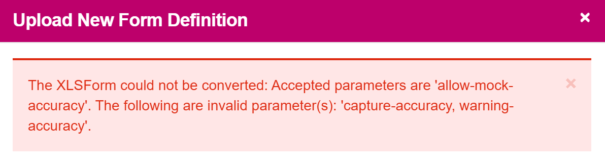
geopointwithappearanceasplacement-map, if the GPS is fast / already has a good fix, it may record a location before the enumerator can select one. I tried to prevent the enumerator from having to clear it and then select the point, by setting the accuracy to an unobtainable value underparameters; in this casecapture-accuracy=1 warning-accuracy=1 allow-mock-accuracy=true, but this had no effect and a value was populated with accuracy of ~15m within seconds. This then submitted with no warnings. - For a
geotraceorgeoshapethecapture-accuracyandwarning-accuracyparameters are not allowed, with this error showing if they are used on either;
- For a
geopoint,geotraceorgeoshapetheallow-mock-accuracy=falsedoesn't work as I expected, when a location is manually chosen, so the accuracy = 0.0, this submitted with no warnings.
2. What steps can we take to reproduce this issue?
Item 1
- Compare raw field value in form (display with
note) to the same value in Central, CSV download & OData query - Test WKT outputs in WKT Playground and WKT Sandbox for validity
Item 2
- Test a form with accuracy parameters to see if they are accepted on form validation (trace/shape) or if they act on the collected values (all)
3. What have you tried to fix the issue?
Item 1
For the difference in CSV/Central/OData I currently have to ensure that I only use one source to get values and transform them into the desired / correct format
Item 2
For preventing point autopopulation I have no solution currently.
For forcing a manual location input, currently to try work around this, I have set constraints instead of using parameters, so if you want to force the user to manually select a geopoint with appearance as placement-map, you can use a constraint to ensure the accuracy value is 0, for a geopoint this is
selected-at(${geopoint}, 3) = 0
However for a geotrace/geoshape, as the resulting string is space delimited but each point is ; delimited, you need to look before the ; so the constraint is (note; this only checks the first point in the line/shape):
substring-before(selected-at(${geotrace_shape}, 3), ';') = 0
This is the opposite of using a constraint to require better GPS accuracy as in the docs, instead of looking for a value under a set radius, you look for it to be 0.