What high-level problem are you trying to solve?
We would like to record the time elapsed and the number of satellites at the point of saving a geopoint, in addition to longitude, latitude, altitude and accuracy.
Any ideas on how ODK could help you solve it?
I have seen that we can use constraint selected-at(${geopoint_widget}, X) < 10, for example when we refer to geopoint X = 1) latitude (decimal degrees), 2) longitude (decimal degrees), 3) accuracy (decimal meters) and 4) altitude (decimal meters) .
I am thinking something like the following, but it didn't work:
type: calculate
calculation: (${geopoint_widget}, 5)
Idem for the number of satellites, but with 6.
Thank you very much.
Upload any helpful links, sketches, and videos.
What questions does this data help you answer? For example, maybe you don't trust the accuracy and you want to see how many satellites were seen as another measure accuracy? Or maybe you've trained enumerators to wait for 5 minutes and you want to see if they actually waited that long.
Hi Yaw,
It is not a relevant data itself related to the project, but we wanted to get those data to compare the GPS receiver accuracies.
In fact, we wanted to test the GPS accuracy in different locations, and using different tablets and other external receivers connected via Bluetooth to the tablets.
We might use other GPS applications to record these data, but as we have an ODK form to test in the field, and rely on ODK for centralizing the data, we wanted to have two tests done at a time.
Anyway, we conducted the test. As the external GPS receiver didn't provide any data on the accuracy at all (always 0 m shown), we gave up on the comparison with the built-in tablet GPS. I am not sure anymore if time elapsed and number of satellites that we thought about to collect are relevant.
Thank you very much for your answer and taking time Yaw.
Fanilo
1 Like
Hi,
I am in a similar situation where I wanted to note how mnay satellites were locked while recording a point or geoshape.
We need this for accuracy measure.
I will be greateful if you can share some solution to note that.
We get accuracy from Android and I'll be surprised if it did not consider the number of satellites in its accuracy calculation. Do you have any evidence to suggest that the accuracy reported by Android to ODK is incorrect?
Thank you yanokwa,
You are right. I didnt mean to say that accuracy is wrong.
I was just looking for a way to demonstrate that geodata is collected with an acceptable accuracy level.
I rechecked the tool and its already meeting our needs. During the manual and auto recoridng accuracy variable is already being saved which is great. Furthermore, one can see the available accuracy at the top before recording.
Thank you for the amazing tool and work.
Thanks for the reply as well.
Hi guys. Thanks for the interesting discussion.
We are also interested in having access to the number of satellite signals used when capturing the coordinates. Two main reasons for this:
- Identify potential issues with the device's receiver that we could not identify by only having the accuracy reading
- Have an idea of how many constellations were visible at the time of taking the reading
Any solutions for this information to be captured would be much appreciated.
Many thanks in advance for that
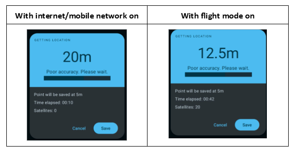
Now that I am thinking about it, would having access to the nbr of sattelite signals not also be a way to identify if the coordinates have been captured using the GNSS receiver vs an internet connection or a mobile phone network?
An example to illustrate that capturing the nbr of satellite would indeed allow us to identify if the coordinates are coming from the GNSS receiver or not (Look at the number of satellites):
1 Like