This feature request has come back to the forefront because:
- In the geo roadmap session at the October convening, a big theme was that users get a lot of value out of collecting single points and that not being able to immediately view those points on a map is a big limitation.
- In conversations about longitudinal data collection at the October convening, it was very clear that viewing previous records on a map is important to many workflows that involve repeat encounters.
- A number of users use GeoODK for this functionality but the GeoODK Collect app is now long out of date.
- Large users that @yanokwa and I are in contact with have expressed need for this (privately for now but hopefully on the forum in the future!)
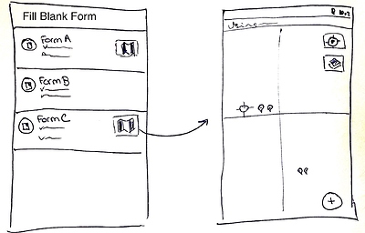
@zestyping has been working on a specification to provide a map view for each applicable form definition. This map view would display all filled form instances currently on the device for that form definition, show the current device position, and provide a button to fill a new form instance.
For this first version of the feature, an applicable form definition is one that has a geopoint question not in a repeat as its first geo question. That is, form definitions that have a geotrace question or a geoshape question or a geopoint question in a repeat as their first geo questions would not currently get a map.
Please see @zestyping’s draft specification for further details.
You can either comment on the specification or respond in this thread. Specification comments are preferred for technical questions and forum comments are preferred for comments or questions about the high-level user experience and functionality.
