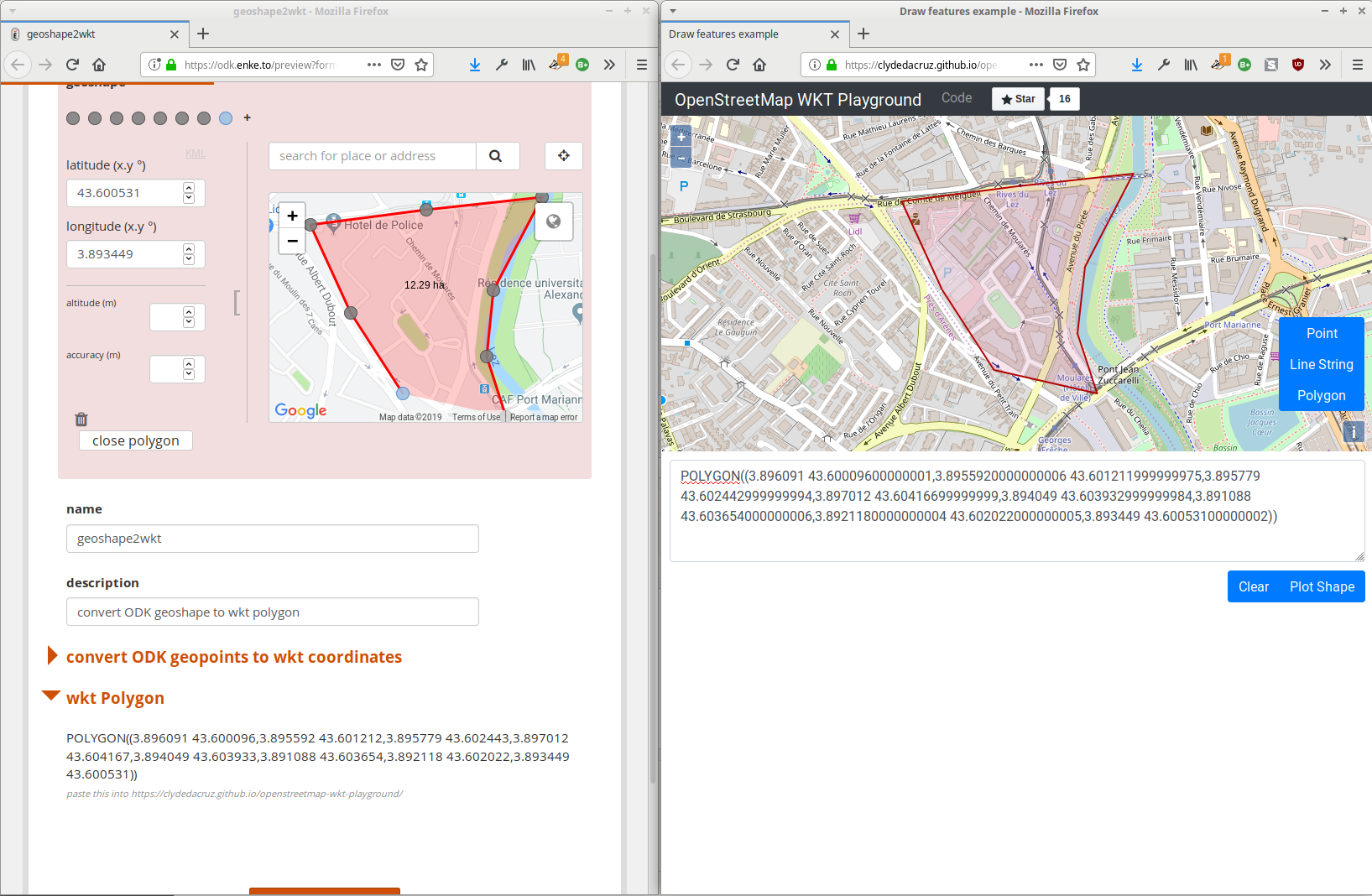
After kml export by @Xiphware and geojson export by @detrygeoffroy, I simply adapted @Xiphware example forms to generate wkt (point, linestring, polygon) from geopoint, geotrace and geoshape odk fields.
In opposition to geojson and kml, WKT does only describes the geometry, it does not contains any attribute value.
So you can collect data and open exported CSV within QGIS with "delimited text layer" tool, choose the column which store wkt, select the projection (4326) and show you data on the map.
Follow Up Question:
The "geoshape2wkt.xls" code shared works very well. Thank you.
However, when testing on a larger area (1 hour perimeter walk generating around 300 GPS points) we have found difficulty in 'saving' the data on the tablet. The tablet requires us to 'swipe left' for each GPS point recorded, which can take a very long time for large areas.
Q: Is there a way to avoid having to swipe left for each and every coordinate recorded?
Thank you,
Hi, @mathieubossaert I'm also facing a similar issue. My form recorded a geo shape successfully which is linked to my Postgres database, When I connect it to Q-GIS it sees it at a database table. How can I see it as polygons on Q-GIS.
Thanks
Hi @Senyo_Aborgah ,
I am quite busy for the next few days so I'll take a look later about why "swipe" is needed
About showing WKT as geometry into QGIS, as far as I know it is only possible with "delimited text" data sources.
If you are using (PostGIS) you should create a view to show a geom column using ST_GeomFromText() function https://postgis.net/docs/ST_GeomFromText.html
Hi @davidbaines,
the problem is due to the note widget that displays current edge's coordinates
I forgot to drop it...
Simply drop it and it will be ok.
Hello Mathieu,
I trust you are well. (France played well yesterday!)
Attached is the most recent version of our generic Land Use Survey in ODK format. It currently automatically calculates the surface area of the Geoshape recorded in the form.
Q: Could you advise on the ODK code we should use to add an automated calculation for the 'perimeter' of the same geoshape? C1.Land_Use_Survey_Generic_v7.xlsx (48.8 KB)
Returns the distance, in meters, of either:

    a nodeset of geopoints
    *the perimeter of a geoshape*
    the length of a geotrace value

It takes into account the circumference of the Earth around the Equator and does not take altitude into account.
I am fine thank you ! Hope you too.
I will spend some time tomorrow during a train trip on ODK (Central french translation to complete) I will try to understand the origin of the problem.
Could you provide some raw string data for both working and not working polygons ? I will see if we could automatically clean it or at least use it.
I had a test to handle cases when geo strings contains '; ' as separator instead of the only semicolon.
This problem occurs sometimes and @davidbaines faced it here :
In such cases, point can be considered as a space-separated list of values with one more space and one more column index. geoshape2wkt.xls (8 KB)
What I'd like to do is be able to collect 1 to many geotraces or geoshapes, and wrap those up as MULTILINESTRING / MULTIPOLYGON outputs (and then at the end combine all point/trace/shape to a GEOMETRYCOLLECTION)
I started with @mathieubossaert's example, adding a repeat to allow multiple traces, but when I try to calculate the string inside the trace repeat, it uses all line vertices from every line, (so if line 1 = A to B to B and line 2 = line D to E, then it returns line 1 = A to B to C to D to E and line 2 = A to B to C to D to E)
I think the solution lies in how to refer to / constrain particular repeat elements (i.e. only take child repeat coordinates if their parent repeat instance = this instance) unless there's a simpler approach to the problem altogether?
Combining points to MULTIPOINT was simpler, and combining the MULTIPOINT with a LINESTRING etc to a GEOMETRYCOLLECTION is also simple.
Yes, what I'd like to do is have repeats for each geotype (point/line/shape) so the enumerator can add as many as required (eg place a point for all corrosion hole anomalies, trace a line along each affected pipe section, draw a shape around all affected areas).
Then bundle each type into a MULTIxxx, and bundle those into a collection, such that the parent submission has all the geo elements wrapped up in a single string. This means I can handle having any number of each geotype finding and won't have to pull the child repeat elements to get the details (unless they also have additional fields associated with them) as they're in GEOMETRYCOLLECTION in the parent form.
The part I'm stuck on is how to create the MULTILINESTRING and MULTIPOLYGON by referring to the particular repeat instances. I have already done the MULTIPOINT and GEOMETRYCOLLECTION steps.
From the above example, the correct output for the MULTILINESTRING would be:
Hi @mathieubossaert geoshape2wkt.xlsx (10.1 KB)
,
I am also looking for a solution. if you see the attached form. the output I am receiving from two repeated geoshape form is as Multipolygon((A B, C D, E F, A B, I J, K L, M N, I J)).
where A,B,C etc are longitude and latitude.
problem: I cannot group the output of a single repeated loop.
What I want:- Multipolygon(((A B, C D, E F, A B)), ((I J, K L, M N, I J))).
your help would be great for me.